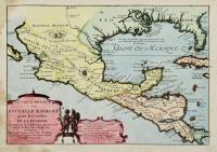
DE FER NICOLAS
Le vieux Mexique ou Nouvelle Espagne avec les costes de la Floride.
Date: Paris,1705
Mexico
P8190011
Subject: Mexico
500,00 €
Copper engraving, mm 232x330. Attractive small map covering the Gulf of Mexico through Central America also including parts of Cuba and Jamaica. It extends through Mexico to show the southern tip of Baja California. This is an early map to show the correct location of the Mississippi River delta gleaned from the expeditions of La Salle and Iberville. Almost all prior maps had the mouth further west into present-day Texas. The Rio Grande (Rio Bravo ou del Nord) is also shown flowing correctly into the Gulf of Mexico rather than into the Gulf of California. Two French forts are located: LaSalle's Fort St. Louis in Texas (Fortbati en 1685) and another near present-day New Orleans. One of the prominent features in northern Mexico is Les Fameuses Mines de Ste. Barbe, the legendary Santa Barbara mines of the Chihuahua-Durango region. The cartouche features two native figures. Nicolas de Fer (1646-1720) was a leading frech engraver and cartographer, official geographer of the king of France. Good condition with a water stain in left margin
Back