ORTELIUS ABRAHAM
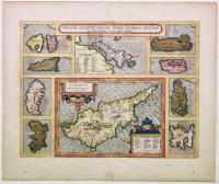
Cyprus, insula laeta choris, blandorum et mater amorum/Insular. Aliquot Aegaei Maris Antiqua Descrip. Ex conatibus geographicis Abrahami Ortelij Antverpiani.
Date: Antwerp,1584 - 1608 about
Cyprus, Greek islands
Cod 34579
Subject: Cyprus, Greek islands
1.100,00 €
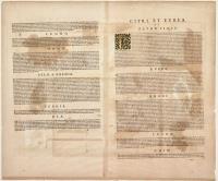
Copper engraving, 360x472 mm, magnificent original period coloring, Italian text on the reverse. The edition with Italian text is particularly rare because it was only published in 1608 and 1612.
Decorative historical map of Cyprus surrounded by nine small maps of the Greek islands (Euboea in the center, Delos and Rhenia, Chios, Ikaria, Rhodes (left) and Samos, Kos, Lesbos, Lemnos (right). Taken from the “Parergon” that Ortelius published as an addition to the “Theatrum Orbis Terrarum,” the first modern atlas, including maps of all areas of the world. Ortelius's brilliant intuition, later Latinized, was precisely this: before then, cartographic production had been irregular and local in terms of production, and the few atlases, the so-called “Lafrerian Atlases,” were compiled on request, collecting maps of some areas and ignoring others. Ortelius brought together the heterogeneous cartographic production of the period into a single corpus, forming the basis for an enormously successful publishing venture, published from 1570 to 1612. Excellent copy with wide margins and slight browning.
Bibliography: Van Den Broecke, Ortelius Atlas maps, 216.
Back