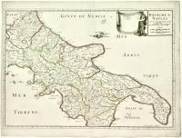
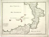
SANSON D'ABBEVILLE NICOLAS
Royaume de Naples
Date: Paris,1703
Regno di Napoli
P4080073
1.000,00 €
A pair of copper engravings forming a map of the United Kingdom, period-colored along the borders, each approximately 415 x 585 mm. This rare edition features erasures in the title, indicating the name of the king who granted the privilege and the printer, with the date changed to 1703 compared to the 17th-century edition. A putto holding the banner has also been added to the map. Sanson, geographer to King Louis XIII, is considered the founder of French cartography and among the first to apply trigonometry to geodetic measurements. Indeed, Nicolas Sanson and his collaborators created new geographic projections and published numerous atlases, while the use of indirect measurement systems was established through the trigonometric procedures applied in Holland by Snellius starting in 1617. Geodetic-topographic surveying based on triangulation quickly gained ground, giving geographical maps an appearance increasingly true to the reality they represented.
Beautiful example with a slight marginal halo at the lower right.
Back