BOSELLI GIOVANNI
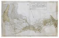
Mappa idrografica del suolo compreso tra il Lago di Garda, Mincio, Poi, e l’Adige dalle Alpi Trentine sino all’Adriatico tratta questa della migliori carte de’ parziali territorij e messa insieme dalla Commissione idraulica del Polesine di Rovigo per servir singolarmentealla conoscenza de’ fiumi, canali, e condotti di scolo di tutte le acque che in esso Polesine decorrono sino al mare.
Date: 1804
Adige, Verona, Polesine
Subject: Adige, Verona, Polesine
9.000,00 €
Finely executed polychrome manuscript in watercolour and brown ink, mm 860x1370, signed lower right "G. Boselli perito e disē.va e dēl.a" (countersigned just above in brown ink by Assalini). An exceptional hydrographic document depicting all the waters of interest in Polesine, from those of Lake Garda to those of the Adige; the territory depicted thus includes the lake, which stands out on the left dominating the map, the Mincio, the Adige from Rovereto to its mouth and the Po from its confluence with the Oglio to the delta. South of the Po, only the Ferrara area is depicted. Below the title in the same box is a legend entitled 'Explanation of the various lines and marked signs' with seven different boundary lines and land types. The iconographic layout of this map presents an exceptional descriptive level with watercolour quality and tonal shading, superior in detail to those outlined in 1700; it also depicts the reliefs of manor houses, valley and stagnant land and fishing grounds. The hydrography of the Adige rivers is precise and includes the vaults, culverts, irrigation channels, drainage channels, and finally the mouths of the respective watercourses. Alongside the water stretches are the place names of the sewers, the wooden and stone bridges, the overflows of the Adige, the cuts to receive the turbid water, the country timber bridges, and the rice fields. On the verso the title is repeated in part and the date of the document (1804) is given. Executed with remarkable finesse, it shows in great detail road information, toponomastic, topographical (remarkable detail in the plan of the details of the settlements) and hydrographical (rivers, canals, culverts), while the mountains of the Verona area are molehills but without any real orographical references as to height and conformation (mountains and hills are not distinguishable), a factor that demonstrates the lack of interest in this purely symbolic aspect. Excellent general state of preservation with a long restoration of about 20 cm to a tear in the white part that does not damage the drawing. Giovanni Boselli, uno dei maggiori cartografi lombardi del periodo napoleonico fu anche autore della importante carta edita a Mantova nel 1801 “Carta topografica della città e territorio di Mantova co’ Paesi confinanti nello stato suo politico sul principio dell’anno 1796”. Questa grande incisione in rame di mm 690x1020 raffigura il territorio mantovano nel 1796. Cfr. Ferrari, Mantova nelle stampe, scheda 354: “E’ molto dettagliata sia nella rappresentazione dell’impianto idrografico che viario ed insediativo. I centri abitati sono raffigurati in prospetto o in pianta, con l’adozione di simboli convenzionali, differenziati in relazione alla loro entità e alla presenza di mura fortificate. Un’ulteriore distinzione è stata impiegata nel tratteggio delle strade comunali e delle strade postali…Essendo il prodotto di mano locale, presenta una notevole correttezza toponomastica.
Back